The best spiral-bound map books make route planning easier, provide dependable offline reference, and help travelers understand the roads and landscapes ahead. This roundup compares 10 options covering nationwide road atlases, scenic drives, national parks, international trip planning, and backcountry navigation.
Whether you need a large-scale atlas for long-distance driving or a specialized guide for Arizona backroads, the right format depends on map detail, portability, durability, and how you plan to use it.
Best 10 Spiral Bound Map Books Picks for 2026
Best World Travel Planning Atlas

- Maps all 195 countries
- Includes flexible trip itineraries
- Adds city maps and planning tools
Best For: International trip planning
Best Compact U.S. Road Map
Easy to Read United States Map

- Clear nationwide highway coverage
- Includes mileage and driving-time maps
- Folds compactly for travel
Best For: Portable U.S. road reference
Best Adventure Road Atlas

- Durable laminated cover and spiral binding
- Features 100 outdoor destinations
- Includes 24 national park guides
Best For: Outdoor-focused U.S. road trips
Best Navigation Skills Guide

- Designed for beginners
- Covers compass and grid navigation
- Explores varied and extreme terrain
Best For: Learning practical land navigation
Best for Easy Reading
Rand McNally 2027 Easy to Read Midsize Road Atlas

- Annually updated maps and travel information
- Flat-laying spiral binding with UV-coated cover
- Portable 8-by-11-inch format with 184 pages
Best For: Readable, portable road-trip planning
Best for Arizona Backroads
GT Arizona Backroads & 4-Wheel
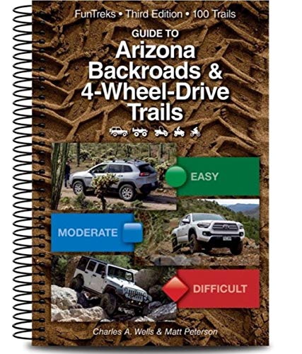
- Covers 100 scenic Arizona backroads
- Includes 236 pages of regional guidance
- Compact 6.6-by-8.9-inch travel size
Best For: Arizona scenic-route and four-wheel-drive trips
Best for Nationwide Coverage

- Updated annually for current road planning
- Includes 378 detailed city inset maps
- Covers U.S. states and Canadian provinces
Best For: Multi-state road trips and city navigation
Scenic-Drive Explorer

- 36 scenic backroad drives
- Guides to 24 national parks
- Compact, glove-box-friendly format
Best For: Scenic-drive travelers wanting a portable atlas
Large-Map Road Tripper

- 35% larger state maps
- 304 pages and 378 city insets
- U.S. and Canadian travel information
Best For: Trip planners who prioritize readable, detailed maps
National Park Planner
Road Atlas & National Park Guide

- Coverage of all 63 national parks
- 132 dedicated park pages
- Spiral binding and UV-coated cover
Best For: National park travelers planning detailed road trips
Best World Travel Planning Atlas – The Travel Atlas
For travelers comparing spiral bound map books with broader trip-planning references, Lonely Planet’s Travel Atlas offers a comprehensive global overview in a substantial paperback format. It combines maps for 195 countries with itineraries, city maps, suggested activities, climate information, and transport details.
Best For: Planning international trips and building multi-country itineraries.
Pros:
- Covers 205 maps across every country on Earth.
- Includes two-day to two-week itinerary ideas.
- Adds city maps, recommended activities, climate details, and transport information.
Cons:
- Paperback rather than spiral bound.
- At 452 pages and 4.58 pounds, it is substantial to carry.
This is a strong choice when trip inspiration and global planning matter more than compact road navigation or a lay-flat binding.
Best Compact U.S. Road Map – Easy to Read United States Map
This Rand McNally folded map is a practical alternative to spiral bound map books when you need a lightweight nationwide road reference. Its clear cartography covers major highways, cities, airports, boundaries, points of interest, mileage, driving times, toll roads, and physical features.
Best For: Drivers who want a compact, inexpensive overview of U.S. roads and travel information.
Pros:
- Shows Interstate and U.S. highways clearly.
- Includes mileage and driving-times information.
- Folds to 4.125 by 9 inches and opens to 25.5 by 36.75 inches.
- Adds airports, points of interest, toll roads, and visitor information.
Cons:
- Folded format is not spiral bound.
- Provides a nationwide overview rather than detailed destination guides.
Choose this map if portability and straightforward highway coverage are more important than a durable bound atlas with extensive regional detail.
Best Adventure Road Atlas – 2027 USA Road Atlas
Among spiral bound map books, National Geographic’s Adventure Edition stands out for road-trip durability and outdoor-focused planning. It combines annually updated maps with 100 adventure destinations, guides to 24 national parks, city maps, and state-by-state travel resources.
Best For: Road trippers combining highway travel with hiking, biking, paddling, climbing, snow sports, or birding.
Pros:
- Uses a laminated cover and spiral binding designed for road use.
- Maps 100 outdoor destinations across the United States.
- Includes in-depth guides to 24 national parks.
- Adds city maps and travel-planning resources for each state.
Cons:
- Focused on the United States rather than international travel.
- Its outdoor emphasis may be more than casual drivers need.
This is the most purpose-built option here for frequent road use, especially when a durable binding and outdoor destination coverage are priorities.
Best Navigation Skills Guide – U.S. Army Map Reading Guide
This U.S. Army guide is less a road atlas than a hands-on navigation manual, making it a useful companion to spiral bound map books. It starts with map care, symbols, grid systems, and aerial-photo interpretation before covering compass work, terrain, day-and-night navigation, and challenging environments.
Best For: Learning map reading, compass use, and land-navigation fundamentals without prior experience.
Pros:
- Assumes no previous knowledge.
- Covers map symbols, grid references, and aerial photographs.
- Explains map-and-compass work across varied terrain and conditions.
- Addresses desert, mountain, jungle, arctic, and urban scenarios.
Cons:
- It is instructional rather than a geographic atlas.
- Contains 100 black-and-white illustrations instead of full-color mapping.
- Published in 2009, so it is not a current road reference.
Buy this for navigation education and field skills, not for up-to-date driving directions or a spiral-bound regional map collection.
Best for Easy Reading – Rand McNally 2027 Easy to Read Midsize Road Atlas
For shoppers comparing spiral bound map books, the Rand McNally 2027 Easy to Read Midsize Road Atlas stands out as a portable, annually updated option for planning U.S. and Canadian road trips. Its 8-by-11-inch format, larger state maps, flat-laying spiral binding, and UV-coated cover are designed for practical use in the car or on the go.
Best For: Road trippers who prioritize readable maps, portability, and current travel-planning information.
Pros:
- Updated annually with current maps, location names, tourism, construction, and toll information.
- Spiral binding lets pages lie flat, while the UV-coated cover adds durability.
- Includes 184 pages, larger state maps, editorial travel ideas, and QR codes for additional trip information.
- Portable 8-by-11-inch size fits a backpack, glove compartment, or travel bag.
Cons:
- Its midsize format may provide less map area than a larger atlas.
- The focus is primarily on U.S. states and Canadian provinces rather than a single regional destination.
This is a strong choice when easy-to-read pages and hands-on planning matter more than having the largest possible atlas. The spiral format and updated editorial content make it particularly useful for active road-trip planning.
Best for Arizona Backroads – GT Arizona Backroads & 4-Wheel
Among spiral bound map books, the GT Arizona Backroads & 4-Wheel guide is a focused choice for exploring scenic routes rather than navigating the entire country. This third edition covers 100 scenic Arizona backroads in a compact 6.6-by-8.9-inch format and contains 236 pages.
Best For: Travelers looking for a dedicated guide to scenic Arizona backroads and four-wheel-drive-oriented exploration.
Pros:
- Focuses specifically on 100 scenic backroads in Arizona.
- Provides a substantial 236 pages of regional material.
- Compact dimensions make it practical to carry on trips.
- Published as a third edition, offering an established guidebook format.
Cons:
- Its coverage is limited to Arizona backroads rather than nationwide routes.
- The supplied details do not confirm a spiral binding, so shoppers should verify the physical format.
- Published in 2020, it is older than the 2027 atlas options in this roundup.
This guide makes the most sense for a destination-specific adventure. Choose it when Arizona’s scenic backroads are the priority, but confirm the binding and make sure its publication date suits your need for current information.
Best for Nationwide Coverage – Rand McNally 2027 Road Atlas
For buyers seeking spiral bound map books with broad coverage, the Rand McNally 2027 Road Atlas combines annually updated road maps with detailed city insets and trip-planning content. It covers U.S. states and Canadian provinces and adds QR codes, tourism information, and 378 city inset maps for route planning.
Best For: Drivers planning multi-state road trips who want extensive city detail and current atlas information.
Pros:
- Updated annually with current road information and location names.
- Includes 378 detailed city inset maps for more urban navigation detail.
- Provides tourism, construction, and toll information for each U.S. state and Canadian province.
- Includes editorial travel suggestions and QR codes for additional trip ideas and tips.
Cons:
- The supplied notes do not specify the atlas’s page count, dimensions, or binding style.
- Its nationwide scope may be more material than needed for a single-region trip.
This is the better general-purpose pick for travelers who value breadth and city-level planning. It offers more inset-map coverage than the midsize edition, while retaining the annually updated road-atlas approach.
Scenic-Drive Explorer – Compact USA Road Atlas
For travelers seeking spiral bound map books for back-road adventures, this compact National Geographic atlas focuses on scenic routes, national parks, and practical trip-planning details. Its smaller format is designed to stay within reach in a glove box, door pocket, or seat-back pocket.
Best For: Road trippers who prioritize scenic drives, national parks, and a portable atlas for travel by car.
Pros:
- Includes 36 curated scenic drives across U.S. backroads.
- Offers in-depth guides and visitor maps for 24 national parks.
- Uses clear, annually updated maps with a visual hierarchy intended to reduce clutter.
- Compact format fits conveniently in common vehicle storage spaces.
Cons:
- Its compact size may provide less room for map detail than a large-scale atlas.
- National park coverage is limited to 24 parks rather than all 63 U.S. national parks.
This is a focused choice for travelers who want inspiration and guidance beyond the interstate. Choose it over a larger atlas when portability and scenic-route planning matter most.
Large-Map Road Tripper – 2027 Large Scale Road Atlas
Among spiral bound map books, the Rand McNally Large Scale Road Atlas is built for readers who want more room to examine routes, destinations, and city details. The 2027 edition provides maps described as 35% larger than the regular Rand McNally road atlas, along with extensive planning content.
Best For: Drivers and trip planners who value readable state maps, numerous city insets, and broad U.S. and Canadian travel information.
Pros:
- Provides 304 pages and state maps 35% larger than Rand McNally’s regular road atlas.
- Includes 378 detailed city inset maps.
- Features tourism, construction, and toll information for U.S. states and Canadian provinces.
- Includes QR codes, seven road-trip itineraries, and updated editorial travel content.
Cons:
- The larger format may be less convenient to carry or store than a compact atlas.
- The supplied notes do not identify a spiral binding for this edition.
This atlas makes the strongest case for shoppers who want legibility and substantial planning coverage rather than a lightweight travel book. Its larger maps and high page count are particularly useful for detailed route research.
National Park Planner – Road Atlas & National Park Guide
For shoppers comparing spiral bound map books with destination-specific guidance, this Rand McNally atlas combines nationwide road maps with coverage of all 63 U.S. national parks. Its spiral binding is designed to let pages lie flat, while the UV-coated cover adds durability.
Best For: National park road trippers who want one large-format guide for routing, park research, and trip planning.
Pros:
- Covers all 63 U.S. national parks in one atlas.
- Devotes 132 pages to national parks, with two to four full-color pages per park.
- Includes 378 city inset maps, QR codes, and annually updated road information.
- Features tough spiral binding, a UV-coated cover, 379 color photos, and 280 total pages.
Cons:
- At about 11 by 15 inches and 2.6 pounds, it is relatively large and heavy for vehicle carry.
- Its extensive park coverage may be more than travelers need for ordinary point-to-point driving.
This is the most comprehensive option for park-focused travelers. The combination of flat-laying spiral construction, full park coverage, and road-atlas mapping makes it especially practical for planning multi-park journeys.
How We Picked the Best Spiral Bound Map Books
We selected these titles for practical coverage across common travel needs: highway navigation, road-trip planning, scenic routes, national parks, international travel, and off-road exploration. We also considered binding convenience, map readability, geographic scope, trip-planning features, and whether each book serves a distinct type of traveler rather than duplicating another atlas.
Publication year matters for road atlases because roads, parks, routes, and travel information can change. Check the edition date before buying, especially if you are planning a long trip or relying on the book as your primary offline reference.
Quick Comparison
| Best For | Look For |
|---|---|
| Cross-country road trips | National coverage, clear highway markings, and an easy-to-use index |
| Large vehicles or detailed route planning | Large-scale pages with more room for local roads and labels |
| Scenic travel | Curated drives, landscape information, and points of interest |
| National park visits | Park-specific maps, access roads, and visitor information |
| Backcountry driving | Detailed local coverage, terrain context, and route descriptions |
| International itinerary planning | Country coverage, regional maps, and suggested trip durations |
Key Buying Factors for Spiral Bound Map Books
Map Scale and Readability
Scale determines how much detail appears on each page. A large-scale atlas can make smaller roads easier to follow, while a compact national atlas is more convenient for broad route planning. Look for clear type, uncluttered symbols, and pages that are easy to scan from a passenger seat.
Coverage and Organization
Confirm that the book includes the states, countries, parks, or backroads you need. A useful index, state or regional divisions, mileage information, and overview maps can save time when building a route or finding an alternate road.
Binding, Size, and Durability
Spiral binding is valuable because pages can lie flatter than standard bound books, but size still affects portability. Choose a larger format for detailed planning and a midsize or compact option for glove-box storage. A sturdy cover and paper that tolerates frequent handling are helpful for extended travel.
Specialized Content
Some Spiral Bound Map Books are primarily navigation tools; others add itineraries, scenic drives, park guides, or off-road advice. Select extras that match your trip instead of paying for information you will not use.
Who Should Buy Which Spiral Bound Map Books?
Choose a comprehensive Rand McNally road atlas for general U.S. driving and route overviews. A large-scale edition suits travelers who prioritize legibility and local-road detail, while a midsize version is a practical compromise for limited storage. National Geographic’s editions are better choices for travelers focused on scenic drives, outdoor destinations, or national parks.
Pick the Lonely Planet atlas for international trip planning and broad geographic inspiration. The U.S. Army guide is aimed at readers who want formal map-reading and navigation instruction rather than a conventional road atlas. For four-wheel-drive exploration, a regional FunTreks guide such as the Arizona backroads title is the more targeted option. If you are unsure, start with the book that matches your primary destination and keep digital navigation as a supplement—not your only source of directions.